

New DFS Rules for Drone Flights in Control Zones: What Has Changed Since August 6
-
Arni -
August 13, 2026 at 3:59 PM -
64 Views -
0 Comments

Where the New Rules Apply, and That's More Airports Than You'd Think
The attached DFS information notice lists 15 airports with DFS aerodrome control: Berlin Brandenburg, Bremen, Dresden, Düsseldorf, Erfurt-Weimar, Frankfurt Main, Hamburg, Hannover, Cologne/Bonn, Leipzig/Halle, Munich, Münster/Osnabrück, Nuremberg, Saarbrücken, and Stuttgart. The legal basis is general ruling NfL 2026-1-3960, which supersedes the previous NfL 2023-1-2705.
What the notice leaves out, and what's easily missed: a second, substantively comparable regulation takes effect at the same time for the control zones operated by DFS subsidiary DFS Aviation Services (DAS), namely NfL 2026-1-3981. It covers Braunschweig, Dortmund, Friedrichshafen, Karlsruhe/Baden-Baden, Lahr, Memmingen, Mönchengladbach, Niederrhein, and Paderborn-Lippstadt, superseding NfL 2022-1-2670 at those locations. All told, then, 24 airports are affected, split across two separate sets of rules. Anyone shooting in North Rhine-Westphalia or southern Germany should therefore check which of the two rulings applies at their particular location.
And a note on what's legally binding: the authoritative source is always the original text of the respective NfL, not the summary. Since March 2026, DFS has made the currently valid NfL available free of charge through its AIP portal at aip.dfs.de/basicAIP, where both rulings can be read in the original.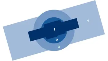
The Core Change: Four Zones Instead of One Control Zone
Until now, a control zone was essentially a single area requiring an application. It is now subdivided into four zones, each with its own rules.
Zone 1 is the inner area: the airspace over the airport itself, plus a lateral distance of one kilometer from its boundary, as well as five kilometers beyond the runway ends, extending one kilometer to either side of the runway centerline. Zone 2 covers the area within a four-kilometer radius of the aerodrome reference point, outside Zone 1. Zone 3 correspondingly covers the six-kilometer radius outside Zones 1 and 2. Zone 4 is the entire remaining portion of the control zone.
What This Means in Practice
In Zone 1, little changes for us: individual clearance is still required at all times, regardless of flight altitude, and must be applied for online at ais.dfs.de. And here's the sentence for your scheduling team: DFS states a processing time of typically 14 days. For same-day ENG assignments, that simply isn't an option, so it has to be built into the planning.
In the outer area, meaning Zones 2 through 4, a general clearance applies instead, provided every condition set out in the NfL is met. The altitude limits are tiered as follows: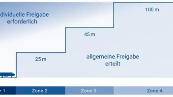
Zone 2: 25 meters above aerodrome elevation or above ground level, whichever is lower.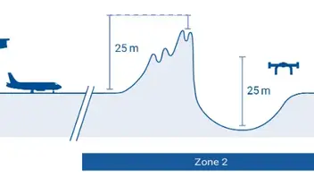
Zone 3: 45 meters, again whichever is lower.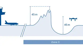
Zone 4: 100 meters above aerodrome elevation or 50 meters above ground level, whichever is higher in this case. If the launch site in Zone 4 lies below aerodrome elevation, the limit is 100 meters above ground level.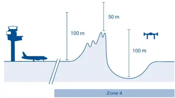
Note the shift in logic: in Zones 2 and 3, the lower figure applies; in Zone 4, the higher one. This isn't sloppiness, it consistently protects downward near the airport while allowing more room further out.
The New Math You'll Have to Do
This is the real change for remote pilots: going forward, you have to determine for yourself which zone you're launching from, how high the terrain is at that point, and how high the aerodrome itself sits. DFS illustrates this with an example based on a control zone with an aerodrome elevation of 48 meters above mean sea level:
If the launch site is at 55 meters, the calculation is 100 minus (55 minus 48), which equals 93 meters; that's more than 50, so 93 meters above ground level applies. If it's at 105 meters, the calculation is 100 minus (105 minus 48), which equals 43 meters; that's less than 50, so the 50 meters above ground level take effect. And if it's at 40 meters, meaning below aerodrome elevation, the limit is simply 100 meters above ground level.
Good news for everyday practice: the new zone boundaries have now been published in dipul. This makes it possible, for the first time, to check Zones 1 through 4 and the resulting maximum altitudes on a location-specific basis, rather than deriving them from the ruling yourself. For terrain elevation at the launch point, DFS recommends its map tool at maptool-dipul.dfs.de. Zones and aerodrome elevations are additionally published in the German Aeronautical Information Publication (AIP IFR).
The Part That's Most Interesting for Our Line of Work: Flying Close to Obstacles
This is where it gets genuinely exciting for architecture, construction, and industrial shoots. In the outer area, there is an additional general clearance for flights conducted close to obstacles, and this applies regardless of the altitude limits described above. A flight qualifies as obstacle-proximate if the drone remains, at all times, no more than 30 meters laterally and 15 meters above an obstacle, explicitly regardless of the obstacle's own height.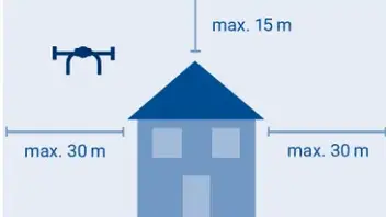
The DFS example makes the significance clear: when flying around a 150-meter wind turbine while observing these distances, 165 meters above ground level is permitted, meaning obstacle height plus 15 meters. In Zone 4, the ceiling would otherwise be 100 meters. Anyone tasked with flying around a transmission mast, a cooling tower, a bridge, or a high-rise near an airport suddenly has considerably more room to work with, provided they stay close to the structure.
The Downside: Manned Traffic No Longer Knows Where You Are
And now for the part missing from most reports on the subject, but central for us as professional users. Alongside the new clearance rules, there is a separate notice covering traffic information (for DAS, NfL 2026-1-3982). Under it, manned pilots flying below 150 meters above ground level who are not on final approach will, as a rule, no longer receive specific traffic information about drones. Instead, they are advised in general terms that drone operations may be taking place below 100 meters at any time.
This is the logical consequence of the liberalization: if nobody files an individual application anymore, the tower no longer knows who is flying where and when. Conversely, this means for us: we likewise receive no traffic information whatsoever about other air traffic from the aerodrome control unit. Within the control zone, we must expect manned and unmanned traffic at any time, we are responsible for collision avoidance ourselves, and we must give way to manned aircraft. Ground visibility of at least 800 meters is also mandatory. Anyone who has ever experienced a rescue helicopter coming in low knows how quickly such a situation can develop.
What Else Is New
The new rules make flights within visual line of sight (VLOS), beyond visual line of sight (BVLOS), and even swarm flights possible in principle. All other prerequisites must of course still be verified before takeoff: operational authorization, no flight restriction areas, geographical zones under Section 21h of the German Air Traffic Regulations (LuftVO), no autonomous operation. It should also be noted that temporary flight restriction areas can be established within a control zone at short notice, so checking current NOTAMs remains part of flight preparation.
And one sentence you shouldn't skim past: there is no entitlement to being granted individual clearance. The aerodrome control unit may attach further conditions to it, refuse it, or withdraw it, particularly when traffic volumes are high.
Bottom Line for Everyday ENG Work
On balance, this is a noticeable relief. Anyone shooting outside the immediate airport surroundings can, in many cases, skip the application process entirely, and obstacle-proximate flying opens up locations that were previously off-limits in practice. The price is personal responsibility on two fronts: you have to know your zone and calculate your altitudes, and you're flying in airspace where manned traffic is no longer individually informed about us. From now on, a look at the map tool and the NOTAMs belongs to location scouting just as much as a look at the weather forecast.
For Zone 1, it remains an application process with a two-week lead time. Anyone regularly shooting near an airport should build this firmly into their production planning; otherwise, that beautiful aerial shot quickly turns into a canceled shooting day.
For further questions, DFS accepts inquiries at futureairmobility@dfs.de. The complete conditions are set out in NfL 2026-1-3960 and NfL 2026-1-3981 respectively, and only those are binding.
Have any of you already gained experience with the new procedures? I'd be particularly interested to hear about obstacle-proximate flying, and how that plays out in practice with clients and insurers.